
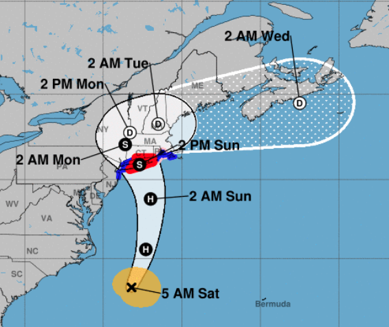
 The latest from the National Weather Service:
A Hurricane Warning remains in effect until further notice. The latest forecast calls for below tropical storm force wind with a peak wind forecast of 25-35 mph with gusts to 50 mph.
There is a threat to life and property that includes typical forecast uncertainty in track, size and intensity: Potential for winds of 74 to 110 mph — The wind threat has remained nearly steady from the previous assessment.
Plan for life-threatening wind of equivalent CAT 1 or 2 hurricane force.
Remaining efforts to protect life and property should be urgently completed. Prepare for considerable wind damage.
Move to safe shelter before the wind becomes hazardous.
POTENTIAL IMPACTS: Extensive – Considerable roof damage to sturdy buildings, with some having window, door, and garage door failures leading to structural damage.
Mobile homes severely damaged, with some destroyed. Damage accentuated by airborne projectiles. Locations may be uninhabitable for weeks.
Many large trees snapped or uprooted along with fences and roadway signs blown over. Some roads impassable from large debris, and more within urban or heavily wooded places. Several bridges, causeways, and access routes impassable. Large areas with power and communications outages.
STORM SURGE – Little to no storm surge flooding. The storm surge threat has remained nearly steady from the previous assessment. But, rough surf, coastal erosion, and life-threatening rip currents are possible.
Little to no preparations for storm surge flooding are needed. Follow the instructions of local officials and monitor forecasts.
A Flood Watch is in effect – Peak Rainfall Amounts: Additional 3-6 inches, with locally higher amounts. The flooding rain threat has remained nearly steady from the previous assessment.
Emergency plans should include the potential for major flooding from heavy rain. Evacuations and rescues are likely. Strongly consider protective actions, especially if you are in an area vulnerable to flooding.
Heed any flood watches and warnings. Failure to take action will likely result in serious injury or loss of life. Extensive – Major rainfall flooding may prompt many evacuations and rescues.
Rivers and streams may rapidly overflow their banks in multiple places. Small streams, creeks, canals, and ditches may become dangerous rivers. Flood control systems and barriers may become stressed.
In hilly terrain, destructive runoff may run quickly down valleys, and increase susceptibility to rockslides and mudslides. Flood waters can enter many structures within multiple communities, some structures becoming uninhabitable or washed away.
Many places where flood waters may cover escape routes. Streets and parking lots become rivers of moving water with underpasses submerged. Driving conditions become dangerous. Many road and bridge closures with some weakened or washed out.
Editor’s Note: Be prepared, and please be careful.
LOST PETS: As with any storm, your pets may become frightened and there is a possibility that some may run away and get lost. If that is the case, let us know ASAP and we will get the word out for you. Over the past 9 years Orange Live has had an excellent record for being instrumental in reuniting lost pets with their families.
If Duke or Fluffy runs away send a photo, time, date, location and your contact information to orangectlive01@gmail.com or text to 203-506-1747. We’ll get the information out to everyone via our website, twitter and 4 Facebook pages. When it comes to pets, this town really rallies for its residents.
All we need in return is to know when you have your pet back home safe and sound.