
 The snowstorm that was expected to hit by 2 p.m. this afternoon is now expected to arrive by 5 p.m. or as late as 7 p.m. this evening.
Heavy snow is expected to fall overnight and continue through tomorrow, tapering off by 1 p.m. Thursday afternoon. The storm is expected to dump 11 to 16 inches of the white stuff on Connecticut and surrounding areas (2 inches per hour), with wind gusts up to 45 mph.
THE LATEST: There is still some uncertainty with how much snow will accumulate if any mixing occurs tonight for southeastern coastal Connecticut. If some mixing occurs, snowfall amounts will be lower.
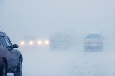
Snow is picking up in intensity with moderate to heavy snow developing. Visibilities will drop from around 1 to 2 miles to a quarter-mile or less at times.
STAY HOME PLEASE! BE SAFE.
A tractor-trailer ban is in effect from 9 p.m. Wednesday to 9 a.m. Thursday and a travel advisory is in effect for all other vehicles.
Charge your phone and computers in the event of a power outage, as an icy mix in some areas may bring down tree limbs and power lines.
As previously stated, travel could be very difficult to impossible and the hazardous conditions could impact overnight travel as well as the Thursday morning commute.
Governor Lamont is asking citizens to stay home during the storm. If you must travel, give yourself plenty of extra time for anticipated delays, drive slowly, and keep a safe distance from other vehicles on the road.
Dress warmly in gloves, face and head coverings, and warm, waterproof footwear.
Tell someone where you are going and when you are expected to arrive, so they will be aware that you may be in trouble and where to find you if you are stuck somewhere.
Also, carry a sturdy ice scraper in your car and keep an extra flashlight, food, water, a blanket or two, and a large empty container (for sanitary needs), in your vehicle in case of an emergency.
Thank you to all of the Public Works and other Plow Drivers who are out there clearing the roads and making them safe for us.