 After plowing into New Jersey and New York last night and early this morning causing substantial flooding, totaling hundreds of parked vehicles, Henri has been downgraded to a tropical storm.
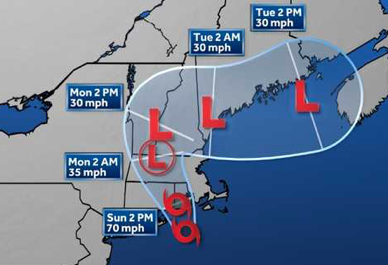
A Storm Surge Warning and Tropical Storm Warning are now in effect for Southern New Haven county and other surrounding areas. The storm carries maximum sustained winds of 70 mph. and is moving north-northwest at 16 mph. It is expected to track into southern New England through Monday while weakening.
The main threats from Henri continue to be potentially life- threatening storm surge, heavy rain capable of producing flash flooding, and tropical storm force winds across southern Connecticut.
Widespread rainfall of 3 to 6 inches is forecast in the path of Henri with localized higher amounts possible. The highest amounts are forecast to occur across Long Island and much of southern Connecticut. Dangerous marine conditions are likely on Long Island Sound.
Potential impacts from the main wind event are now unfolding across eastern Long Island and southeast Connecticut. Remain well sheltered from dangerous wind having possible significant impacts. If realized, these impacts include: some damage to roofing and siding materials, along with damage to porches, awnings, carports, and sheds.
A few buildings experiencing window, door, and garage door failures. Mobile homes damaged, especially if unanchored. Unsecured lightweight objects become dangerous projectiles.
Several large trees snapped or uprooted, but with greater numbers in places where trees are shallow rooted. Several fences and roadway signs blown over. Some roads impassable from large debris, and more within urban or heavily wooded places. A few bridges, causeways, and access routes impassable.
Scattered power and communications outages, but more prevalent in areas with above ground lines.
On the coast, areas of inundation with storm surge flooding accentuated by waves. Damage to several buildings, mainly near the coast. Sections of near shore escape routes and secondary roads become weakened or washed out, especially in usually vulnerable low spots. Flood control systems and barriers may become stressed. Major beach erosion with heavy surf breaching dunes. Very dangerous surf and rip currents.
Moderate damage to marinas, docks, boardwalks, and piers. Several small craft broken away from moorings, especially in unprotected anchorages.
Potential impacts from the flooding rain are still unfolding across Southeast New York, Northeast New Jersey, and Southern Connecticut. Remain well guarded against life-threatening flood waters having additional extensive impacts.
If realized, these impacts include: Major rainfall flooding may prompt many evacuations and rescues. Rivers and streams may rapidly overflow their banks in multiple places. Small streams, creeks, canals, and ditches may become dangerous rivers. Flood control systems and barriers may become stressed.
In hilly terrain, destructive runoff may run quickly downhill and increase susceptibility to rockslides. Flood waters can enter many structures within multiple communities, some structures becoming uninhabitable or washed away. Many places where flood waters may cover escape routes. Streets and parking lots become rivers of moving water with underpasses submerged. Driving conditions become dangerous. Many road and bridge closures with some weakened or washed out.
Potential impacts from an isolated tornado or two are still unfolding across southeast Connecticut as rain bands move onshore. Remain prepared for a tornado event having possible impacts. If realized, these impacts include: the occurrence of isolated tornadoes can hinder the execution of emergency plans during tropical events.
A few places may experience tornado damage, along with power and communications disruptions. Locations could realize roofs peeled off buildings, chimneys toppled, mobile homes pushed off foundations or overturned, large tree tops and branches snapped off, shallow rooted trees knocked over, moving vehicles blown off roads, and small boats pulled from moorings.
Listen to local officials for recommended preparedness actions, including possible evacuation. If ordered to evacuate, do so immediately. For those not under evacuation orders, assess the risk from wind, falling trees, and flooding at your location.
If you decide to move, relocate to a safer location nearby. If you do not relocate, help keep roadways open for those under evacuation orders. If evacuating, leave with a destination in mind and allow extra time to get there. Take your emergency supplies kit.
Gas up your vehicle ahead of time. (NOTE: A lot of stations are currently out of gas) Follow designated evacuation routes. Seek traffic information on roadway signs, on the radio, and from official sources. Let others know where you are going prior to departure.
Secure loose items and pets in the car, and avoid distracted driving. Do not enter evacuated areas until officials have given the all clear to return.
OTHER PREPAREDNESS INFORMATION: Now is the time to stay inside and away from windows. Listen for updates and be ready in case you lose electrical power. Keep a battery powered radio, charged cell phone and flashlight handy. During the peak of the storm be ready to move quickly. Keep your shoes on and rain gear handy. Boots and athletic shoes offer the best foot protection if you become unexpectedly exposed to the weather.
Keep your cell phone charged and in power saving mode. If you lose power, use it sparingly and mainly for personal emergencies and checkins. If you are prone to flooding or in an area under a storm surge watch or warning, be prepared for the possibility of a quick and dramatic rise in water levels. If a tornado warning is issued for your area, quickly move to the safest place within your shelter. Protect your head and body. *
IF this is a serious storm in our area, be safe and good luck everyone.
I hope everyone prepared well in advance for any scenario and that you fare well throughout the day, night and next few days. Be well. Keep in touch!
